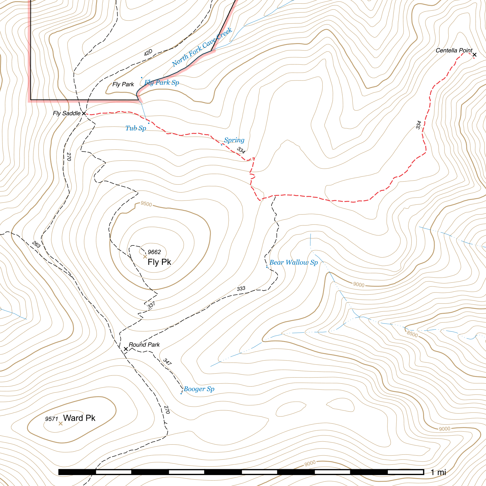
Centella Trail #334
Important Note
Some old sources name the western segment of the Centella Trail from Fly Saddle to Centella Junction the "Tub Spring Trail".
Current Trail Conditions
As of May 2019, this trail is free of deadfall following a Sierra Club service trip.
Length: 1.63 mi
Difficulty: easy
Condition: good
Elevation range: 9045 ft – 9335 ft
Access
The Centella Trail can be accessed from two locations.
The trail begins at Fly Saddle, (31.87965, -109.28665) a junction along the Crest Trail which is also the southern terminus of the Long Park Trail and the northern terminus of the Fly Peak Trail. To reach Fly Saddle from the trail junction above Rustler Park, travel south on the Crest Trail 2.37 miles. Alternatively, from Long Park, follow the Long Park Trail southwest for 0.68 miles.
If approaching from the south, a shorter route to Centella Point is to take the 0.81 mile Bear Wallow Trail from Round Park (31.86842, -109.28480) and connect to the Centella Trail midway at Centella Junction. (31.87582, -109.27772) Centella Point lies to the right and Fly Saddle to the left.
Trail Description
Fly Saddle to Centella Junction
- 0.75 mi
- 280 ft ↑ / 55 ft ↓
- 5.7% slope
The Centella Trail begins at Fly Saddle, (31.87965, -109.28665) the five-way junction where the Crest Trail passes through in two directions and the Long Park Trail, Centella Trail and Fly Peak Trail fork off in their own directions.
The first tenth of a mile passes through raspberry thickets off which berries can be enjoyed in the summer, provided the bears haven't harvested them already. It's another tenth of a mile to Tub Spring, (31.87919, -109.28363) which lies south of the trail and flows across it. A dry, abandoned concrete trough is fifty feet north of the trail opposite the spring. Another spring, this one small and undeveloped, can sometimes be seen right beside and across the trail in another quarter mile. (31.87818, -109.28023)
Over the next quarter mile, the trail makes a couple small switchbacks and climbs to about the top of a ridge. The Centella Trail makes a 90° turn to the west-northwest here, (31.87559, -109.27846) while an abandoned trail to Fly Peak heads straight up the ridge roughly to the southwest and disappears shortly after. It's only 250 feet down a small slope from this bend to Centella Junction, (31.87582, -109.27772) where Centella Trail continues east and the Bear Wallow Trail to Bear Wallow Spring and Round Park heads south. This junction is signed and easily visible.
Centella Junction to Centella Point
- 0.89 mi
- 95 ft ↑ / 75 ft ↓
- 0.4% slope
A tenth of a mile after leaving Centella Junction, the trail exits tree cover onto the sparsely forested Centella Ridge. (31.87577, -109.27615) A prescribed burn took place in this area in the late 1980s, and it burned again in 1994 and 2011. Over the next approximately half a mile the ridge curves gradually to the north and the trail follows. As you get further along the ridge, you can begin to get a good view of the northeast side of Fly Peak. Keep an eye out for a rock outcrop just east of the trail a little after it re-enters a lightly forested area—it provides a good shaded lunch spot with great views. (31.87998, -109.27039) It's only another two tenths of a mile from there to Centella Point, (31.88222, -109.26846) a well exposed location and helispot with a panoramic view of the Cave Creek Basin and beyond. No evidence of the former Forest Service lookout tower at this site remains.
Map
Last updated May 17, 2019.