Horse Trail
Important Note
This trail only appears on one map1, but it is mentioned by name on a burned sign at Wood Canyon Saddle along the Indian Creek Trail, as well as a sign near the southern terminus of the same trail (note that this sign lists a vastly incorrect distance of 1 mile).
A portion of this trail lies within the boundary of the Chiricahua National Monument, where dogs are not allowed. The boundary is marked by a fence which the trail passes through.
Current Trail Conditions
As of August 2018, this trail has had some of its deadfall removed, and is reasonably well-marked with rock cairns and flagging, but it remains quite faint and does still have deadfall and overgrowth, as well as several confusing points with forks and disappearing tread.
Length: 1.08 mi
Difficulty: moderate
Condition: bad
Elevation range: 6855 ft – 7210 ft
Access
The Horse Trail can be accessed from two locations.
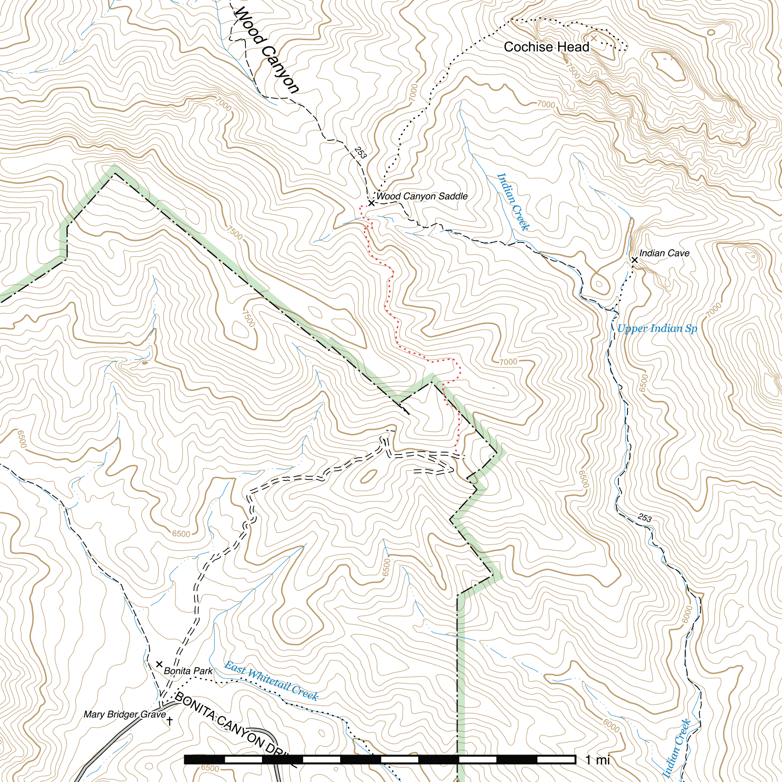
The northern terminus departs from the Indian Creek Trail at Wood Canyon Saddle, the ridge separating Wood and Indian Canyons. (32.05209, -109.30961) The route to Cochise Head heads north from this point as well. A pair of signs mark this junction, but the one mentioning the Horse Trail by name is badly burned and is mostly unreadable.
The southern terminus is within the Chiricahua National Monument on the north side of the end of the King of Lead Mine Road, roughly a quarter mile above the King of Lead Mine itself. The faint trail drops down a ridge to this point. There is no sign at this end and the trail is difficult to see from the road. (32.04102, -109.30580)
Trail Description
The trail descends almost immediately from the southern edge of Wood Canyon Saddle, very briefly heading south before swinging west, then switchbacking to the south-southeast again after 190 feet. Another 190 feet later, the descent ends upon crossing a drainage, and the trail begins its primary climbing portion. A switchback is encountered after 225 feet, with three more across the next 170 foot segment. No additional switchbacks are encountered, but the trail does remain relatively steep as it ascends the northeastern slope of the ridge dividing Indian Canyon from the Chiricahua National Monument. After approximately 0.15 miles, the trail briefly levels out and a clearing is reached. The path can be quite faint here, but it picks up again 150 feet beyond on the south edge of the clearing and continues contouring along the ridge due south for a while, dropping down slightly, then largely remaining level as it begins to angle east 0.24 miles later. Over the next 0.3 miles initially heads southeast, then east, before proceeding to cross a ridge and curve south, then south west, then south again until it reaches the Monument boundary where a pedestrian gate must be passed through. The next 900 feet skirt around a small peak before dropping 200 feet down a ridge to the King of Lead Mine Road.
Map
Footnotes
- Chiricahua Mountains, Arizona — A Trail and Recreation Map, Rainbow Expeditions, 7th Edition, 1997
Last updated August 31, 2018.