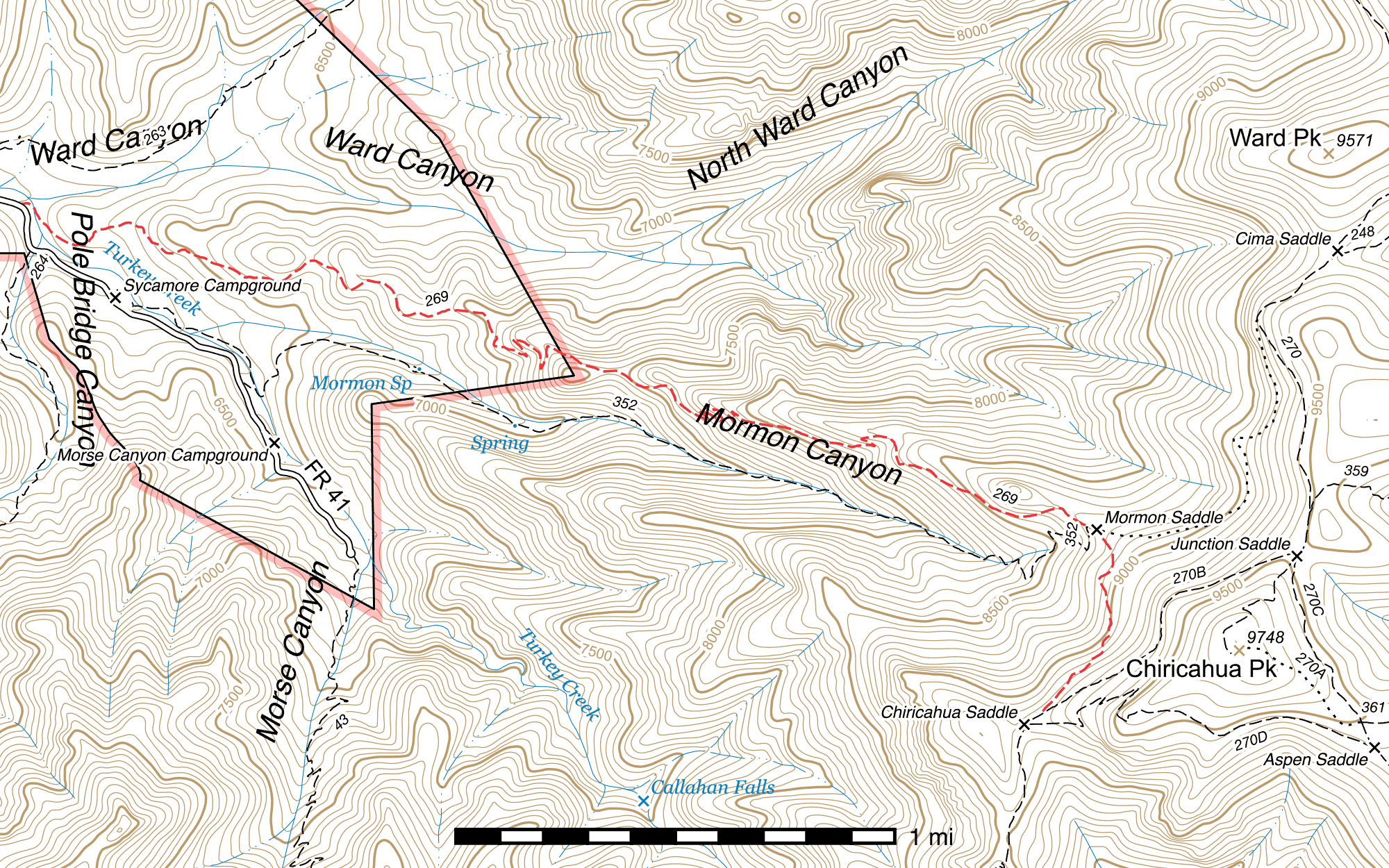
Mormon Ridge Trail #269
Current Trail Conditions
As of May 2019, the Mormon Ridge Trail is passable to hikers but has intermittent deadfall, especially concentrated around and above the junction with the Mormon Canyon Trail at Mormon Saddle, and remains quite brushy in the switchbacks.
Length: 4.1 mi
Difficulty: moderate
Condition: moderate
Elevation range: 6145 ft – 9135 ft
Access
The Mormon Ridge Trail is accessible from three locations.
The lower-elevation western terminus lies at a signed trailhead with single car pull-off (31.86319, -109.33852) on the east side of the Turkey Creek Road (FR 41), 0.36 mile northwest of Sycamore Campground.
The Mormon Canyon Trail, the lower elevation counterpart to the Mormon Ridge Trail, connects in after 3.51 miles at Mormon Saddle. (31.85061, -109.29674) This is a faint but partially signed junction.
The higher-elevation eastern terminus is a signed junction 250 feet northeast of Chiricahua Saddle along the Crest Trail. (31.84346, -109.29888)
Trail Description
Trailhead to Mormon Saddle
- 3.51 mi
- 2,600 ft ↑ / 60 ft ↓
- 13.7% slope
From Turkey Creek Road (FR 41), the Mormon Ridge Trail drops to the east for 170 feet before coming to a crossing at Turkey Creek. (31.86319, -109.33800) Here, the trail briefly appears to disappear, but simply cross the creek heading southeast and you will shortly pick it up again. Over the next mile and a half the trail climbs gradually up Mormon Ridge, frequently contouring around the terrain. There are excellent views up Mormon Canyon all the way to Chiricahua Peak through this area.
The next 1.32 mile stretch contains twelve switchbacks in three distinct and evenly-spaced groups, and is the steepest portion of the hike. A burned sign near the last set of switchbacks can no longer be read but once marked the former location of the Wilderness boundary. (31.85387, -109.30597) After the final switchback, (31.85413, -109.30583) you will pass a rock formation resembling a turtle (31.85301, -109.30357) on the north side of the trail in 1000 feet, and from there it is just under ½ mile along the ridge to the signed junction at Mormon Saddle, (31.85061, -109.29674) where the Mormon Ridge Trail swings right and continues to the south, the Mormon Canyon Trail heads sharply back to the west right alongside the segment of the Mormon Ridge Trail you just came up, and the abandoned Upper Mormon Ridge Trail can be seen heading out to the east.
Mormon Saddle to Chiricahua Saddle
- 0.59 mi
- 335 ft ↑
- 10.7% slope
Out of Mormon Saddle, the Mormon Ridge Trail curves to the south and contours along the western face of Chiricahua Peak while gradually climbing. It maintains this general course its entire length, passing through aspen and pine, and several burned areas. There are several very tangled areas with trees down all over each other through here, but the trail remains visible and fairly easy to follow. Towards the end, it almost parallels the Crest Trail while climbing towards it. The upper terminus is at a signed junction (31.84346, -109.29888) 250 feet northeast of Chiricahua Saddle.
Map
Last updated May 2, 2019.