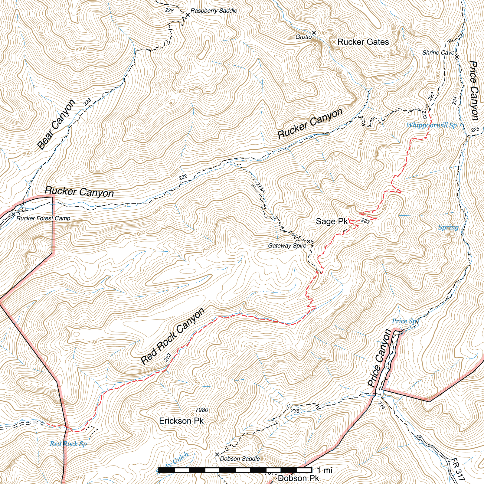
Red Rock Canyon Trail #223
Important Note
This was once called the Red Rock Canyon Trail for the first segment that passes through that canyon, then the Sage Peak Trail from the point where it begins climbing to the ridge until its northeastern terminus at the Rucker Trail. Some signs still use the old Sage Peak Trail name despite the entire trail now using the former.
Length: 5.04 mi
Difficulty: difficult
Condition: bad
Elevation range: 6380 ft – 8335 ft
Access
The Red Rock Canyon Trail is accessible from three locations.
The southwestern terminus is at the end of Red Rock Canyon Road. As this road is very rough and in poor condition, and because the first few miles of the trail are atop a former logging road, it is difficult to determine the true trailhead. From Highway 80, turn northwest onto Tex Canyon Road 29 miles northeast of Douglas, AZ, or 19 miles southwest of the AZ/NM border south of Rodeo, NM. (31.59386, -109.23945) After 6 ¾ miles, this road crosses the National Forest boundary and becomes Forest Road 74. Continue 9.1 miles to a junction with the Rucker Canyon Road. (31.75675, -109.37018) Take the right fork (FR 74E) and follow it for 3.3 miles before coming to a junction with the Red Rock Canyon Road (marked with a Red Rock Canyon sign). (31.76575, -109.32814) This road is relatively rough. Turn right and travel half a mile before coming to a fork. (31.76086, -109.33365) Take the more heavily traveled left fork and immediately after, cross the creek. Turn left again at the next fork which lies 150 feet beyond. (31.76050, -109.33315) After 0.16 miles, the road makes a sharp bend to the right and climbs a steep slope. (31.76149, -109.33114) You may park and walk from here, or continue along the road as far as you are comfortable driving the remaining 2.1 miles to the real trailhead. (31.76134, -109.29999) There is no sign at the trailhead and there is extensive flood damage to the road in places.
Midway along the trail, ½ mile southwest of Sage Peak, there is a junction with the Upper Rucker Canyon Trail, (31.77807, -109.26942) which ascends along 2.1 miles and 44 switchbacks from the main Rucker Trail at a point 1.7 miles past its trailhead. (31.79065, -109.28002) There is no sign or indication of a trail for some distance at its lower junction, but its upper junction with the Red Rock Canyon Trail is signed.
The northeastern terminus is along the Rucker Trail, 3.88 miles from its trailhead, at the top of the ridge between Rucker and Price Canyons. This junction is signed. (31.79611, -109.25741)
Trail Description
Trailhead to First Switchback
- 2.35 mi
- 1,225 ft ↑ / 10 ft ↓
- 9.8% slope
From a bend in the road at a creek crossing and a large boulder, the road turns into the Red Rock Canyon Trail and continues up the canyon floor. The first few miles of trail follow an old logging road, so it may look as though the road continues beyond this point. After a little over a quarter mile, a sign for Red Rock Spring can be seen, buried in a rock and gravel flow right up to the bottom of the text, on the right side of the trail. (31.76052, -109.29642) The springbox which was once here has been buried completely, only a trace of the black plastic pipe which connected it to the true spring above visible in places. 60 feet further along the trail is the Wilderness boundary sign, also partially buried.
After an additional approximately 100 feet, there is a fork. (31.76070, -109.29589) A large rock cairn or two mark this point. The Red Rock Trail takes the less visible left fork, while a much more visible road heads east and after nearly a quarter mile with several steep climbs and switchbacks, arrives at the true location of Red Rock Spring. (31.75967, -109.29517) The box and pipe used to capture the water and transmit it to the point along the trail below are still visible, but were also damaged by the flooding and are out of operation. It may still be possible to find water flowing at this location, however.
Back on the Red Rock Canyon Trail, it heads northeast away from the fork for 320 feet before crossing the creekbed and maintaining the same direction on the other side of the creek for a time. The old roadbed remains largely visible through here, and the canyon is relatively narrow, so it's easy to follow the generally correct route even if it fades occasionally. 1.7 miles from the first creek crossing after the fork, the wreckage of the first of three aircraft which crashed in this area in the 1940s can be seen among other debris in the creekbed a few feet off the right hand side of the trail. (31.77271, -109.27436) Another creek crossing occurs soon after and the trail climbs higher on a slope above the creek for a little while. A third of a mile beyond the plane crash site, two signs mark the point where the trail exits Red Rock Canyon. (31.77426, -109.26994) Note that all signage from here to the northern terminus refers to the trail as the Sage Peak Trail.
First Switchback to Upper Rucker Canyon Trail
- 0.47 mi
- 475 ft ↑ / 45 ft ↓
- 17.4% slope
Here, a sharp switchback to the west occurs and the trail begins a steep climb up the canyon slope to the ridge above. After 5 switchbacks across a quarter mile of trail, you will reach a saddle atop the ridge. (31.77591, -109.27109) From here, you can view both Red Rock and Rucker Canyons, as well as the entrance of Price Canyon and the San Simon/San Bernardino Valley beyond, Dobson and Erickson Peaks one canyon south of Red Rock Canyon, and on an especially clear day, mountains in Mexico to the southeast.
The trail then heads northeast along the slope on the opposite side of the ridge, passing through a section of extremely tall pines before swinging to the left, making a single switchback, and climbing to another saddle. Just before the saddle, the Upper Rucker Canyon Trail departs to the northwest and connects to the Rucker Trail below. (31.77807, -109.26942) This trail is marked with a sign and is quite visible at the junction, but is very infrequently used, has flood damage lower down, and can be difficult to follow at times.
Upper Rucker Canyon Trail to Sage Peak Spur
- 0.44 mi
- 270 ft ↑ / 35 ft ↓
- 10.2% slope
30 feet northeast of the Upper Rucker Canyon junction lies the saddle proper, where a fallen trail sign lists inaccurate milages to destinations, some of which no longer exist. From here, the trail is not immediately obvious, but it heads roughly north for about 200 feet before making a sharp left turn to the west indicated by a small sign with an arrow (31.77866, -109.26918) and shortly after curving back to the north-northwest where it becomes possible to follow again. Curving along the ridge as it climbs, another saddle of sorts is reached after 0.27 miles. (31.78211, -109.26800) A truly spectacular panoramic view of Rucker Canyon can be had here. A little under 150 feet beyond, the trail bends to the east and continues for 250 feet before turning back to the north and climbing the ridge towards Sage Peak. Here, the trail grows faint. After 100 feet, a faint fork may be seen. (31.78267, -109.26695) The Sage Peak Trail turns east again via the right fork, while the left fork is an unofficial route to the top of Sage Peak, 350 feet beyond. Occasional rock cairns mark that route. A wooden sign at the peak commemorating Harley Sage, the ranger who the peak is named after, has partially burned and fallen off its post. (31.78325, -109.26616) The view from here is excellent.
Sage Peak Spur to Rucker Trail
- 1.79 mi
- 330 ft ↑ / 1,056 ft ↓
- 7.7% slope
Heading east out of the fork, the trail angles northeast after 120 feet and contours along the southeast side of Sage Peak, a short distance below the top. After 230 feet, you will reach the highest point in this trail. (31.78303, -109.26603) If coming from the other direction, this might be a better spot to take off towards the peak rather than descending to the spur and re-ascending.
Now descending, the trail continues northeast for 270 feet before coming to a switchback (31.78337, -109.26530) and heading northwest. Three more switchbacks over the next 580 feet, and after exiting the third you'll briefly head southeast before curving east for 0.19 mile to another switchback, then another 0.12 mile after. Then it's a gradual descent east, curving north around a basin and climbing back up to a ridge 0.29 mile beyond. Another switchback 0.1 mile east of the ridge, through an area that's somewhat difficult to follow in places, then the trail descends to the northwest, arcing northeast along the top of a ridge where no trail is visible in places and onto a saddle with several rock spires and a tremendous view. (31.78889, -109.26128)
The trail drops down to the east here, going through a short switchback shortly after and then heading northeast on the east side of the ridge, crossing it again at a saddle 0.19 mile later. From here it continues almost north around a hill, crossing its northwest face after 0.17 mile and turning east for 0.1 mile to a point just above a saddle where it makes two small switchbacks, (31.79320, -109.25769) the first turning west and the second northeast. These are quite faint and can be easy to miss.
The final 0.23 mile to the Rucker Trail junction are relatively easy to follow. The trail sticks on the west side of the ridge for a short distance before making its way to the top of it and running down the spine. Rock cairns mark the route in faint places along here. Approaching the rock formations above the junction, it drops down on the west side of the ridge again. The junction takes place at the base of those rocks, below natural caves that resemble cliff dwellings. There are two signs here. (31.79611, -109.25741)
Taking the left fork of the Rucker Trail takes you back out Rucker Canyon 3.88 miles to the trailhead. Taking the right fork will keep you atop the ridge a while before dropping to the Price Canyon Trail in 0.68 mile. This segment of trail is not currently in good condition and can be difficult to follow at the end.
Map
Last updated May 3, 2017.