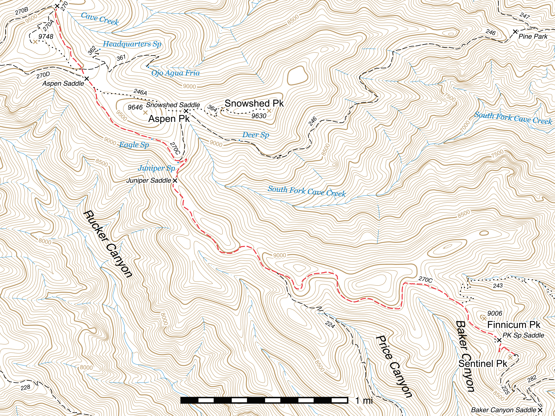
Crest Trail - Junction Saddle to Sentinel Peak #270C
Important Note
The sign at Junction Saddle for this trail says 270B rather than 270C, but other, older signs at Aspen Saddle and elsewhere confirm it is 270C.
Current Trail Conditions
As of October 2020, this trail has been cleared of deadfall from Junction Saddle to the junction with the South Fork Trail. The switchback between Juniper Spring and Juniper Saddle has been completely restored and widened, as it had been significantly damaged by erosion and lack of use. Elsewhere, tread conditions are highly variable—sometimes very visible and easy to walk on, other times virtually nonexistent. The worst tread currently is while crossing the top end of Baker Canyon. Beyond the South Fork junction, this trail has not been surveyed for several years and conditions are unknown, but hikers have been making it to the top of Sentinel Peak recently.
Length: 4.94 mi
Difficulty: moderate
Condition: moderate
Elevation range: 8770 ft – 9500 ft
Trail Description
Junction Saddle to Aspen Saddle
- 0.57 mi
- 45 ft ↑ / 70 ft ↓
- 0.8% slope
This fork of the Crest heads south out of Junction Saddle (31.84959, -109.28897) and gradually angles south-southeast as it passes east of Chiricahua Peak. While the Horseshoe II fire passed through here, it didn't cause extensive damage, and old growth remains. After a little over a third of a mile, the trail emerges out of tree cover and enters an area burned in the 1994 Rattlesnake Fire and largely cleared of dead trees by Horseshoe II in 2011. Another 700 feet and the Ojo Agua Fria Trail, (31.84315, -109.28646) marked by a sign, takes off to the east. Two great water sources, Ojo Agua Fria and Headquarters Spring, lie down this trail, making Aspen Saddle (31.84265, -109.28561) a great place to camp. The abandoned eastern portion of the Chiricahua Peak Trail connected in near here as well. The Aspen Saddle junction (31.84217, -109.28597) lies 400 feet further along the Crest, where the Chiricahua Peak Bypass heads northwest. This junction is also marked with a sign.
Aspen Saddle to Snowshed Trail
- 0.87 mi
- 30 ft ↑ / 335 ft ↓
- 6.7% slope
The Crest heads out of this junction, gradually descending, with a spectacular view into Rucker Canyon and beyond. After about 400 feet, the abandoned Aspen Trail heads southeast to Snowshed Saddle. This junction is not signed and is not easily found, especially with aspen growth taking off post-fire. The remnants of telephone line wires and a tree with gate hinges can be found near here as well.
Over the next 0.44 mile, the trail transitions from heading south to southeast, contouring around the south face of Aspen Peak. Another faint, abandoned trail can be seen near here, taking off on the uphill side of the trail and heading east. (31.83664, -109.28094) This was once the original route of this trail, which cut over to Snowshed Saddle rather than dropping to Juniper Saddle as the modern route does. 1
It's only another 200 yards down-trail from this old trail remnant to Eagle Spring, which is marked by a sign bolted to a dead tree stump (31.83599, -109.27911) and which lies downslope at the end of a 60 foot spur. This spring is reasonably reliable, especially in spring and fall, but can get slimy due to full sun exposure at this location.
Nearly a quarter mile down a relatively steep descent (which you won't notice so much until you climb back up it heading the other direction), the trail turns east and arrives at the Snowshed Trail upper terminus. (31.83381, -109.27650) A Crest Trail signpost without a sign can be found here, as well as a Snowshed Trail sign on a tree. Snowshed takes off to the north-northeast, while the Crest Trail continues on, making a switchback to the southwest.
Snowshed Trail to Price Canyon Trail
- 1.31 mi
- 170 ft ↑ / 300 ft ↓
- 1.9% slope
Descending out of the junction, it's only 90 feet to Juniper Spring and the next switchback. (31.83361, -109.27663) This spring is quite unreliable, somewhat out of repair, and often has the round lid to the springbox knocked loose and rolled down the hill somewhere nearby by a bear. If you plan to get water in this area, Eagle Spring is a much better bet. A faint path continues southwest from the spring to a viewpoint into Rucker Canyon, but the main trail switchbacks northeast for 300 feet, then again southwest for 900 feet before reaching Juniper Saddle, (31.83177, -109.27695) the low point in the descent from Aspen Saddle.
Crossing the saddle, the trail angles southeast and contours along the south face of the ridge, climbing for a bit before roughly leveling out. After 0.6 mile, it curves east, then northeast, as it wraps around the southeast side of a high point on the ridge and enters the first of three similar-feeling "bowls" at the head of canyons along this route. After 0.19 mile, it crosses a saddle and curves back southeast, transitioning back into contouring along the south face of the ridge.
After another 0.28 mile from the "bowl" or saddle, you'll come to the signed junction with the Price Canyon Trail. (31.82237, -109.26655) As the primary traffic for the Crest Trail comes up via this junction, trail conditions beyond this point degrade significantly due to decreased use.
Price Canyon Trail to South Fork Trail
- 1.59 mi
- 95 ft ↑ / 270 ft ↓
- 2.1% slope
After a brief climb and continuation of the same southeastern contouring, the trail makes a complete U-turn around the end of another high point on the ridge after 0.18 mile and heads into another saddle, this time at the top of Price Canyon. Crossing this saddle in 0.31 mile, the trail turns due south before resuming yet another segment of contouring along the south side of the ridge. In just over half a mile, it turns sharply north, entering a particularly low grade section of tread, with grass growing into the path as it descends towards the final "bowl" at the top of Baker Canyon. Crossing the head of this drainage in 1000 feet, the trail passes over a potential washout point where water flows across it, then turns east and heads for the spine of the ridge, dropping the remaining 0.37 mile to the South Fork Trail junction. (31.81918, -109.24792) The trail along here can be a little vague and confusing, and it's easy to mix up the real trail with an old firebreak at times. If in doubt, the real trail is usually not the one that suddenly climbs directly up the spine of a steep ridge.
South Fork Trail to Sentinel Peak Junction
- 0.6 mi
- 195 ft ↑ / 100 ft ↓
- 3.0% slope
The South Fork Trail junction occurs a few feet west of two tall, dead trees. (31.81918, -109.247919) The westernmost of these has two new signs bolted to it.
The Crest Trail heads southeast out of this junction along a largely barren ridge. This region was burned heavily in years past and the 2011 Horseshoe 2 fire cleared out much, but not all, of the remaining dead wood. There are numerous scattered pine and fir saplings, promising a return to forest in the distant future—but for now the ridge, and Finnicum Peak to the northeast of the trail, have a distinct grassy appearance. The absence of trees here means this segment of trail gets incredibly powerful wind blasting over it, so be prepared to hold on to your hats.
Almost immediately past the junction, a faint path can be seen climbing to the top of Finnicum Peak. This is a remnant of a firebreak and is not a trail. 0.37 miles beyond, at PK Spring Saddle, (31.81547, -109.24386) the firebreak drops back down to the Crest Trail. This saddle, named for a historic spring in the canyon below, was once also the site of a trail dropping to said spring. There is only a faint trace of the trail remaining, and the spring is long gone.
From the saddle, the trail swings south and begins climbing towards Sentinel Peak's talus slopes. It crosses one briefly, then switchbacks three times. The southeastern terminus lies 400 feet beyond the final switchback at a three-way junction (31.81406, -109.24235) with a 420 foot spur trail to the top of Sentinel Peak, and the Baker Canyon Trail, which drops below to the Horseshoe Ridge Trail, the Jones Ridge Trail and the Price Canyon Trail a few miles below.
The fire lookout atop Sentinel Peak has been long removed, but its foundation and a metal plaque in its honor can still be seen. The view from the top is about the best in the region.
Map
Footnotes
- USGS, Chiricahua Quadrangle (1:125000), 1919
Last updated October 12, 2020.