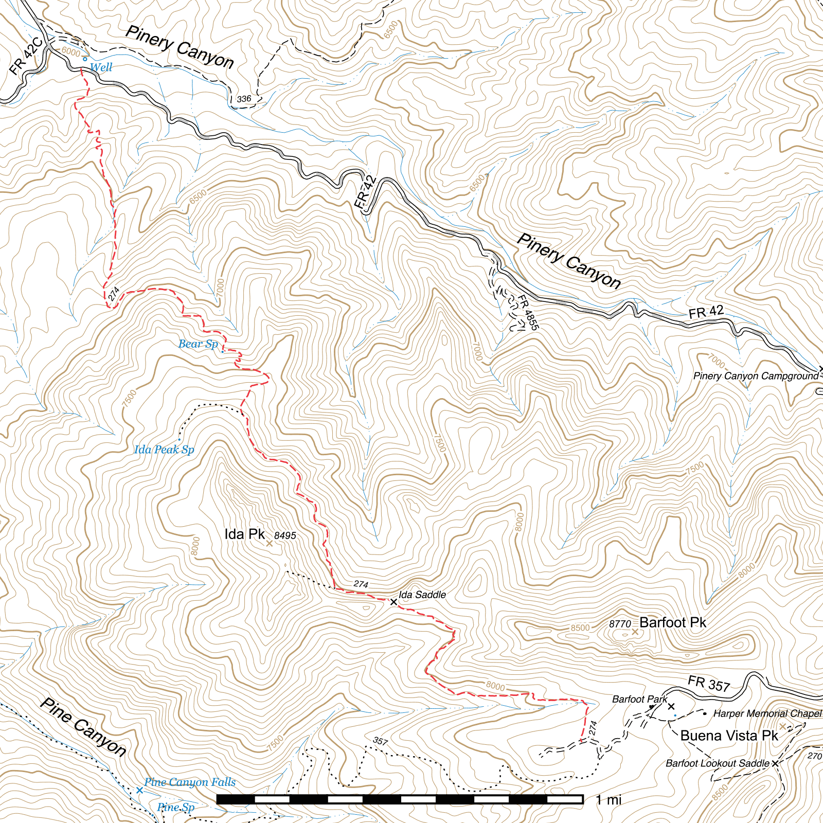
Ida Peak Trail #274
Current Trail Conditions
As of April 2017, the lower mile and a half of trail has been cleared of deadfall and extensive brushing and tread improvement was done in areas, as well as some erosion control mitigation. A large number of trees remain across the trail above Bear Seep.
Length: 3.68 mi
Difficulty: difficult
Condition: bad
Elevation range: 6080 ft – 8150 ft
Access
This trail can be accessed from two locations.
The lower-elevation northern terminus is in Pinery Canyon, on the south side of Pinery Canyon Road (FR 42), 0.12 miles southeast of the junction with Downing Pass Road (FR 42C). (31.94710, -109.30640) The trail is marked by a sign on each side of the road. Parking can be found just north of the aforementioned junction where a road leads to an undeveloped campsite and the western terminus of the Pinery-Horsefall Trail.
The higher-elevation southern terminus is just below Barfoot Park. Follow Barfoot Park Road (FR 357) past the meadow and turn right at the sign for the Barfoot Helispot. The Ida Peak Trail begins 450 feet beyond, on the right side of the road. (31.91579, -109.28312) There is a sign at the trailhead, but as of September 2014 it has fallen over and can be easy to miss. If you reach the helispot, you have gone too far. The Barfoot Park Road becomes quite rough after passing the meadow, and is closed to vehicular traffic just after the turnoff to the Barfoot Helispot, so it is advised to park near the meadow and walk the rest of the way to the trailhead.
Trail Description
From the edge of Pinery Canyon Road, this trail begins climbing almost immediately and while there are occasional stretches that briefly level out between here and Ida Saddle, be prepared for a lot of uphill. At this elevation, the trees are largely oak and occasional madrone.
The first two thirds of a mile are spent alternating across several drainages and ridges. At the last of this set of ridges, you will reach a badly fire and flood damaged region, and the trail becomes less clear for a short while. The trail drops into a drainage from the north, descending down a slope for 300 feet and then continuing up-drainage. If you lose track of the trail, it begins to climb out of the drainage to the right after approximately 750 feet and should become visible again at that point. A short distance later it bends to the left and crosses the drainage higher up before turning north-northwest and climbing for nearly 300 feet.
From there, the trail begins skirting around the mountain, climbing as it does so. The next 650 feet head east before angling generally to the southeast for 0.37 miles, contouring into drainages three times along the way. At the end of this stretch, a set of four switchbacks over a 300 foot segment of trail elevate you above a steep slope. The next 0.29 miles involve a wide U-turn from east to west followed by a steep climb to the south which ends up at a grassy clearing once marked by a sign indicating this was the location of the Ida Burn, a 1953 wildfire. This sign burned in 2011, but traces of it may still be visible on the east side of the trail. A primitive route to Ida Peak Spring cuts across the clearing from here, heading southwest for approximately 0.2 miles.
Continuing on the trail, you'll parallel the eastern edge of the Ida Burn a short distance before entering the pine forest that remains the norm until the upper terminus at Barfoot Park. Fire did reach this area, but large stands of pine still remain. Occasional trees are fallen across the trail and care needs to be taken to avoid slipping on thick mats of needles in areas where the trail's tread has eroded somewhat.
The next 0.63 miles resume contouring along Ida Peak in a southwesterly direction, climbing nearly the entire time. At the end of this stretch, where the trail makes a nearly 90° turn to the left before making its last push to Ida Saddle, an extremely steep primitive route to the top of Ida Peak takes off to the west-northwest. Ida Saddle lies 0.17 miles east-southeast. The saddle was heavily burned in 2011 and few, if any, living trees remain.
The burn continues for the next half mile as the trail drops down the other side of the saddle and contours around the west side of a ridge before returning to pine cover and leveling out. You'll pass through the middle of a tall pine meadow where the trail can disappear somewhat in the grass. Keep heading east and you'll pick up the trail again on the other edge. After approximately 800 feet the trail bends to the south for 120 feet as it climbs onto a shelf above a creek (usually dry) and then resumes its eastward course. After 750 feet on the edge of the slope above the creek, it crosses it and turns south for the remaining 700 feet to the terminus along the Barfoot Helispot Road. The last stretch of this is often matted with pine needles, obscuring the actual trail, so rocks have been placed along it to mark the route.
Map
Last updated May 3, 2017.